Category: Spatial Databases

Shape
End of Term Assignments

Routing on a Spatial Database – End of Term Assignment

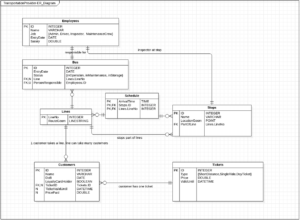
Using pgRouting, a navigation functionality is implemented based on a spatial database of a fun fair, where the user can input his or her position and be routed to a nearest Point of Interest. A Python DB connector dynamically creates the SQL queries and visualizes the results.

Read More »
Spatial Databases

Data Model of (Spatial) Database

Imagining a relational database for a public bus operator, conceptual and logical databases model are created. The goal is to visualize the entities and their relationships within this scenario.

Read More »
Spatial Databases

Managing Roles in PostgreSQL

In this exercise, some role managing and security operations are performed. Roles are created, given permissions and view queries created that allow managing the restriction of information within a database.

Read More »
Spatial Databases

SQL for Spatial Queries

In this exercise, some basic GIS functionalities are performed with SQL/PostGIS commands, such as Union, Intersect and Buffer.

Read More »